Elsa Noterman (Queen Mary University of London) and Camilla Penney (Te Whare Wānanga o Waitaha | University of Canterbury)
Access to universities is often framed as a question of admissions tests, tuition fees, and socio-economically hostile environments, which lead to inequities in enrolment and graduation. Underpinning these inequities, though, is a more tangible lack of access; access to the land owned and controlled by educational institutions.
University land ownership has complex, often violent, histories. Many universities have gained property through enclosure—the fencing off of common land (e.g. Guillebaud 2005)—or the dispossession of Indigenous people via land seizure and coercive treaties (High Country News 2020). Building construction and endowments have been funded from the profits accrued by chattel slavery, extorted wealth, and colonial land expropriation (see e.g. Advisory Group on Legacies of Enslavement 2022). This violence persists into the present day; the ongoing acquisition of land by academic institutions often displaces and unsettles local residents as a result of artificially inflated property prices and changes to policing regimes and land-use policies (Baldwin 2021).
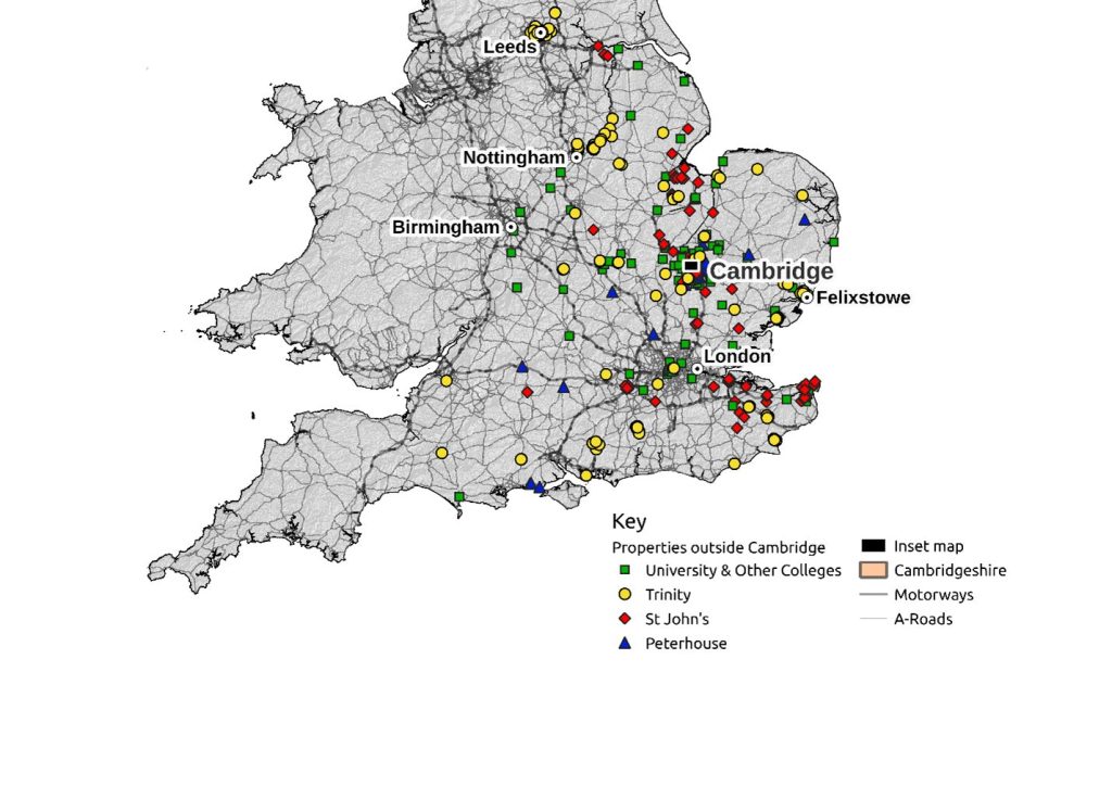
Land ownership can also produce and exacerbate inequities between institutions of higher education. For example, in the UK, the Universities of Oxford and Cambridge hold about 80% of all university-owned land (Barbiroglio 2018). A 2018 Guardian investigation found that the constituent colleges of Oxford and Cambridge together own over 126,000 acres of land in the UK (more land than is owned by the Church of England), with a property portfolio worth an estimated £3.5 bn in total (Greenwood and Adams 2018) – a portfolio that includes investment properties, such as Felixstowe Port (see Figure 1). Extensive historic and contemporary landholdings have significantly contributed to Oxbridge’s consolidated net assets of around £21bn—more than the other 22 institutions that make up the Russell Group of top UK research universities combined (Adams and Greenwood 2018).
Sources: FOI requests; topography from NASA Shuttle Radar Topography Mission (SRTM 2013); UK road map data © Ordnance Survey Ltd 2023 licensed under the Open Government Licence v3.0
As research fellows at the University of Cambridge, we were confronted by the economic inequities, spatial inaccessibility and colonial histories which constitute the violent underpinnings of these university property regimes, as we sought to navigate, and live in, a divided city.[1] Cambridge’s urban landscape is interrupted by parcels of university space, shut off from the public by ornate—and effective—gates and walls. The iterative “no” of these ostentatious barriers—“no entry”, “no access”, “no walking on the grass”—makes the city difficult to navigate, not only for newcomers but also for long-term residents with no connection to the university (see Figure 2). At the same time, the walls of the colleges and the brevity of student degrees limit students’ physical exposure to, and imagination of, the town.
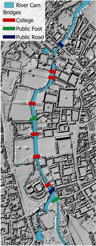
The “Town and Gown divide” in Cambridge, which has at times been officially policed,[2] was legally carved into the landscape through the Cambridge St Giles enclosure act of 1802 (Guillebaud 2005). This fencing off of common land has led to a long history of hostility as well as income inequalities, with the city ranked as the “least equal” in the UK (Centre for Cities 2018: 60).[3] A recent news report highlighted that some children living in Cambridge have never seen the River Cam that flows through it and gives the town its name (Spencer 2022). This disconnection has arisen in part because several colleges of the university have privatised both the view and the use of the river by building along its banks and barring free access by non-university members.
Living in the city, and amidst a period of heightened awareness of inequitable access to land during the Covid-19 pandemic (e.g. The Ramblers’ Association 2020), we found ourselves, as members of the university, reflecting on our complicity in the maintenance of these property regimes. This reflection led us to three key questions:
- How can we, as (often precarious) university employees, support ongoing efforts to democratise access to university land, and advance land-use and ownership policies which address both present-day inequities and calls for rematriation and reparation?
- How can we, as teachers, integrate questions of land justice into our teaching and learning, beginning with an analysis of our own educational institutions?
- How can we responsibly include students in community-engaged research?
These questions provided the inspiration for “Accessing Land Justice” (2022), a project with a principal aim of developing pedagogical practices and tools in pursuit of land justice through community-engaged research. Specifically, we wanted to focus on issues of access and equity raised by university land ownership, both as a means of challenging the university’s role in maintaining the socio-spatial division of the city, and of reckoning with the ways the place we worked and taught had benefited from the “economics of empire” (Gopal 2021) and enclosure.
Wanting to mobilise—while thinking critically about—the tools currently available to resist ongoing enclosure, and to support relationships to the land that do not foreground exclusion or possession, we looked to public rights of way as an initial point of intervention. In UK law, a public right of way is the right to “pass and repass” over a particular route, which may cross private property, and, as such, provide crucial routes for accessing natural spaces, commuting, and recreation. Although such rights have existed in common law since the enclosure of common land began, they have only been formally recognised in law—and required to be registered—since the National Parks and Access to the Countryside Act 1949. This Act required each local authority to create a “definitive map” of rights of way in its jurisdiction, which, since the Wildlife and Countryside Act 1981, must be kept under continuous review, with the onus on members of the public to provide evidence for the historic existence of rights of way to have them registered, and thus protected for future generations. As such, making sure that more public rights of way are legally recognised constitutes an actually-existing possibility for enhancing public access to land.
There is, however, a time limit to this possibility. The Countryside and Rights of Way Act 2000 set a deadline of 1 January 2026 for the addition of historic rights of way to the definitive map of each local authority.[4] At the deadline, public rights of way which existed prior to 1949 and which remain unclaimed will no longer be officially recognised, meaning that the estimated 49,000 miles of paths which remain unrecognised are under imminent threat of being lost to public access. In response to the impending deadline, a charity, The Ramblers, launched a major project to save these paths, “Don’t Lose Your Way”.[5] The Ramblers suggest that preserving and expanding these paths is an equity issue given that, as found in recent research, the answer to the question “Who has a right of way in England and Wales today?”, is “the old, the wealthy, the healthy, and the white” (Chapman et al. 2022: 2).
Reading Nick Hayes’ The Book of Trespass (2020), we were struck by the amount of labour required to preserve these public rights of way. Compiling the necessary “definitive map modification orders”, or DMMOs, often requires materials from multiple archives—including hard-to-access collections, such as those held by universities—as well as legal and technical knowledge (Bucks and Wadey 2012). Yet ongoing efforts to preserve these rights, previously inherent in common law, are undertaken entirely by volunteers who share accumulated knowledge and advice via websites and listservs. We thought that involving students in this labour of evidence collection for DMMOs would be a route into thinking about historical and contemporary issues of land justice, as well as a practical mechanism for opening up access to University land.
We developed the project in consultation with members of the Cambridge branch of The Ramblers, who had already undertaken a great deal of work, and recruited undergraduate students for paid summer internships. Together we visited archives and collected and analysed evidence to preserve and expand public rights of way on land owned by the University of Cambridge and its colleges in and around the city. We also prepared several definitive map modification orders to recognise and protect historic rights of way on this land, and appealed to two of the largest land-holding colleges—Jesus and Trinity—to voluntarily dedicate two additional rights of way on their land in recognition of documented extensive community use [6].
Of course, as Nick Hayes points out in The Book of Trespass (2020), whilst rights of way “enshrine a public right” to space, they “simultaneously legitimise the space that is off limits, the private right”, leading Hayes to argue that “[o]ur ‘rights’ to the land have become streamlined into thin strips of legitimacy, the freedom to toe the line”. Throughout the project we recognised the limitations of DMMOs, which hold the potential for preserving access to narrowly defined paths and roads, rather than broader forms of access, such as the Right to Roam, that allows anyone to roam in open countryside regardless of who owns the land. Legally recognising historic rights of way will not, for instance, grant access to the River Cam.
Yet working on definitive map modification orders did allow us to identify some of the tools and privileges which we could access. As members of the University of Cambridge community (however provisional), we had easier entry than non-members to archives such as those of the university colleges, where some key evidence for preserving public rights of way—as well as information about broader land holdings—could be found. We were also able to use funding opportunities available through the university to pay undergraduate students as summer researchers to work on the project and to provide honoraria to local groups whose work focuses on increasing access to land for food and shelter. In so doing, we were able to rebalance the scales in a small way: by not dedicating specific funds or labour to the preservation of public rights of way, the Countryside and Rights of Way Act 2000 placed an enormous burden on unpaid volunteers to do the work necessary to retain them, in effect stacking the deck against the public and in favour of landowners. By repurposing the resources available through our positions within the university, we sought to expand access to university land, and to understand the extent of these land holdings. As put by Mayorga et al. (2019: 101): “those of us who stay [in academic institutions] can ‘lawfully’ access the exclusive privileges of academia but then convert it into resources for use of the public/our communities, against the wishes, and independent, of the university”.
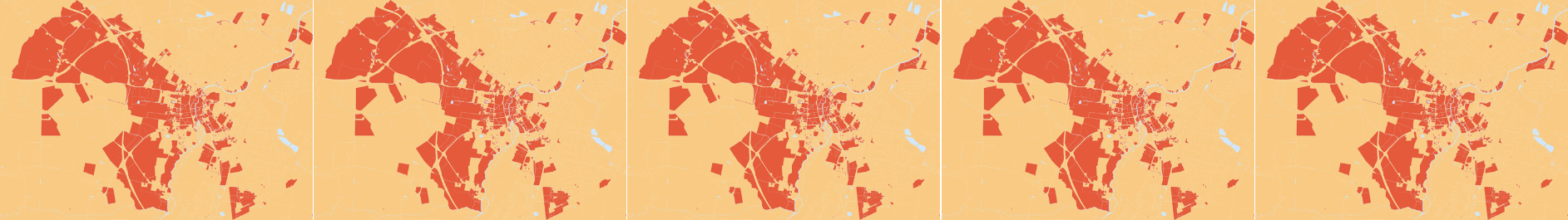
We also looked to expand the project remit beyond public rights of way, to broader issues of land justice. Current and former students of Cambridge, as part of the “Landlord University” project, had already been working to understand the extent of university land ownership through freedom of information (FOI) requests, which allow members of the public to query data held by public institutions including Oxford and Cambridge colleges. Working with these students, we mapped this ownership in the city (Figure 3) and further afield (Figure 1). Through an ongoing campaign, “Cambridge Land Justice,” that emerged out of these projects, this data is supporting activism and organising within and beyond the university. The campaign is building networks of action; addressing the university as a landlord to both students and residents, investigating the violent dispossessions underpinning historical and contemporary university land acquisition, and collectively producing alternative visions of university land use that address community needs— across the “town and gown” divide—for housing, food, recreation, and repair.

Sources: FOI requests; Cambridgeshire County Council Section 31(6) Statutory Declarations; Office for National Statistics licensed under the Open Government Licence v. 3.0. This information is subject to Crown copyright and database rights [2022] and is reproduced with the permission of HM Land Registry. The polygons (including the associated geometry, namely x, y co-ordinates) are subject to Crown copyright and database rights [2022] Ordnance Survey 100026316. Contains OS data © Crown copyright [2022] licensed under the Open Government Licence v3.0
To encourage similar actions beyond Cambridge and to future colleagues, we also co-designed an open-source curriculum on land justice and the process of creating definitive map modification orders. This curriculum both serves as a tool of future pedagogy and was a method to enable the students working on the project to reflect on what they had learned and to think about how such lessons might be conveyed to others interested in this work. Finally, we collaborated with two artists to develop a short animated film about the land ownership of the University of Cambridge and its colleges (see Montague et al. 2022).
The ever-expanding web of people and organisations we have engaged with through this project has made it clear that land forms a nexus, underlying and connecting multiple struggles. To redress the inequities of current systems of land access and ownership it is, therefore, critically important to trace and build on historic and ongoing efforts to pursue land justice. This tracing is not only through time—following histories of resistance in a particular place—but also across space, as both land expropriation and struggles for reclamation connect across the globe. More and more people are pushing back and taking up space—advocating for the preservation and expansion of public rights of way, and beyond them for the Right to Roam; cultivating forms of collective ownership, such as through community land trusts (CLTs); opening space by creating village and town greens, as in the work of the Open Spaces Society; and struggling for land reparations and spatial justice, as seen in the work of Land In Our Names and the Black Land and Spatial Justice Project.[7] In addition, scholars are increasingly contributing to efforts to understand and account for academic institutions’ colonial land histories (such as the Land-Grab Universities project; High Country News 2020) and participation in urban displacement—the creation of “UniverCities” (Baldwin 2021). Alongside these efforts are calls for a vision of decolonising universities that is grounded in “giving the land back” (Curley and Smith 2020). In this context, a question for researchers, educators and students is how we can use our teaching, learning and research, as well as our privileged access to resources and information, to contribute to efforts to redress the inequities of land ownership and access in our institutions and beyond. Our experience through the “Accessing Land Justice” project suggests that, with the guidance of long-standing activists and broader communities, actively engaging students and repurposing the resources of our universities against their own land holdings offers a means of making demands on our institutions to not just critically consider, but materially change their relations to land ownership and access.
Acknowledgements
We would like to thank and recognise those that participated in and contributed to the Accessing Land Justice project. We greatly appreciate the support of the Cambridge Ramblers, especially their guidance in researching and preparing DMMOs—and a special thanks to Paul Cutmore and Jill Tuffnell. Our three student research interns, Rosalind Cooper, Claudia Davey, and Anna Gardner, were key to this project—collecting evidence, preparing DMMOs, and producing educational resources. And finally, (former) student Harvey Brown meticulously researched university land ownership and continues to organise through the Cambridge Land Justice campaign. We received funding for the project from: an Economics and Social Sciences Research Council social impact fund grant, the British Geophysical Association outreach fund and the University of Cambridge equality and diversity fund.
Endnotes
[1] At the time we initiated this project (January 2022), we were both Junior Research Fellows at Queens College at the University of Cambridge.
[2] City bailiffs swore to “uphold the privileges of the university” from 1317 (Lambert 2021) and the Universities Act 1825 allowed vice-chancellors of Oxford and Cambridge to appoint constables with jurisdiction within four miles of their respective universities. See https://www.legislation.gov.uk/ukpga/Geo4/6/97 (last accessed 29 September 2023).
[3] In 2018, the lower 20% of earners made 2% of all income generated by residents, while 19% of this income was taken home by the highest 6% of earners.
[4] See https://www.legislation.gov.uk/ukpga/2000/37/section/56 (last accessed 2 November 2023). This deadline has recently been extended to 1 January 2031, after the Department for Food and Rural Affairs (DEFRA) first promised to remove the deadline entirely, then reinstated it (see Open Spaces Society 2023; The Ramblers’ Association 2023).
[5] See The Ramblers’ Association’s “Don’t Lose Your Way” campaign: https://dontloseyourway.ramblers.org.uk/ (last accessed 29 September 2023).
[6] This documented use was undertaken in both cases by nearby residents who conducted surveys and interviews. While our initial appeals have been unsuccessful, we plan to continue to push university and college landholders to increase access to their land.
[7] See https://www.oss.org.uk/; https://landinournames.community/; and https://twitter.com/BLSJustice (last accessed 29 September 2023).
References
Adams R and Greenwood X (2018) Oxford and Cambridge university colleges hold £21bn in riches. The Guardian 28 May https://www.theguardian.com/education/2018/may/28/oxford-and-cambridge-university-colleges-hold-21bn-in-riches (last accessed 22 September 2023)
Advisory Group on Legacies of Enslavement (2022) “University of Cambridge Advisory Group on Legacies of Enslavement—Final Report.” https://www.cam.ac.uk/about-the-university/advisory-group-on-legacies-of-enslavement-final-report (last accessed 3 August 2023)
Baldwin D L (2021) In the Shadow of the Ivory Tower: How Universities are Plundering Our Cities. New York: Bold Type Books
Barbiroglio E (2018) Oxbridge totally dominates university land ownership. Property Week 5 July https://www.propertyweek.com/analysis/oxbridge-totally-dominates-university-land-ownership-/5097527.article# (last accessed 9 September 2023)
Bucks S and Wadey P (2012) Rights of Way: Restoring the Record. Corsham: Bucks & Wadey Publishing
Centre for Cities (2018) “Cities Outlook 2018.” https://www.centreforcities.org/wp-content/uploads/2018/01/18-01-12-Final-Full-Cities-Outlook-2018.pdf (last accessed 3 August 2023)
Chapman A, Prabhu P and Scott A (2022) “Who has a Public Right of Way? An Analysis of Provision and Inequity in England and Wales.” New Economics Foundation https://cdn.ramblers.org.uk/media/files/volume-1-who-has-public-right-way-new.pdf (last accessed 2 November 2023)
Curley A and Smith S (2020) Against colonial grounds: Geography on Indigenous lands. Dialogues in Human Geography 10(1):37-40
Greenwood X and Adams R (2018) Oxford and Cambridge university colleges own property worth £3.5bn. The Guardian 29 May https://www.theguardian.com/education/2018/may/29/oxford-and-cambridge-university-colleges-own-property-worth-35bn (last accessed 3 August 2023)
Gopal P (2021) On decolonisation and the university. Textual Practice 35(6):873-899
Guillebaud P (2005) The enclosure of Cambridge St Giles: Cambridge University and the Parliamentary Act of 1802. Proceedings of the Cambridge Antiquarian Society 94:185-198
Hayes N (2020) The Book of Trespass: Crossing the Lines that Divide Us. London: Bloomsbury
High Country News (2020) “Land-Grab Universities—A High Country News Investigation.” https://www.landgrabu.org/ (last accessed 3 August 2023)
Horton H (2023) Right to wild camp in England lost in Dartmoor court case. The Guardian 13 January https://www.theguardian.com/environment/2023/jan/13/dartmoor-estate-landowner-alexander-darwall-court-case-right-to-camp (last accessed 29 September 2023)
Lambert T (2021) “A History of Cambridge.” https://localhistories.org/a-history-of-cambridge/ (last accessed 4 April 2023)
Mayorga E, Leidecker L and Orr de Gutierrez D (2019) Burn it down: The incommensurability of the university and decolonization. Journal of Critical Thought and Praxis 8(1):87-106
Montague J, Hanna S, Noterman E and Penney C (2022) “Open the Gates.” Cambridge Creative Encounters Shorts https://tinyurl.com/LandJusticeShort (last accessed 17 November 2023)
Open Spaces Society (2023) Coffey kowtows to landowners and destroys public-path consensus. 25 October https://www.oss.org.uk/coffey-kowtows-to-landowners-and-destroys-public-path-consensus/ (last accessed 2 November 2023)
Spencer A (2022) The Cambridge children who have never seen the River Cam. Cambridge Independent 28 January https://www.cambridgeindependent.co.uk/news/the-cambridge-children-who-have-never-seen-the-river-cam-9237379/ (last accessed 29 September 2023)
SRTM (2013) “Shuttle Radar Topography Mission (SRTM) Global.” OpenTopography https://doi.org/10.5069/G9445JDF (last accessed 4 July 2023)
The Ramblers’ Association (2020) “The Grass isn’t Greener for Everyone: Why Access to Green Space Matters.” https://cdn.ramblers.org.uk/media/files/ramblers-access-nature-11_0.pdf (last accessed 26 October 2023)
The Ramblers’ Association (2023) Government breaks promise to scrap deadline for saving lost paths. 23 March https://www.ramblers.org.uk/news/government-breaks-promise-scrap-deadline-saving-lost-paths (last accessed 29 September 2023)